|
|
|||||||||||||||||
| Point ID: 5852 | Downloads | Plots | Site Data | Code: 10MB004 |
|
|
|||||||||||||||||
| Download | |
|---|---|
| Site Descriptor Information | Site Time Series Data |
| Link to all available data | |
| View: | Time Series | All |
| Units: | mm |
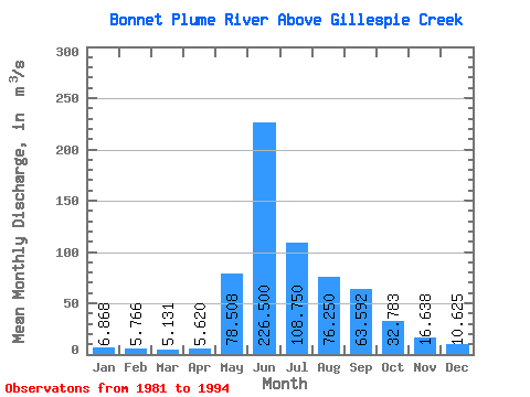
| Statistic | Jan | Feb | Mar | Apr | May | Jun | Jul | Aug | Sep | Oct | Nov | Dec | Annual |
|---|---|---|---|---|---|---|---|---|---|---|---|---|---|
| Mean | 6.87 | 5.77 | 5.13 | 5.62 | 78.51 | 226.50 | 108.75 | 76.25 | 63.59 | 32.78 | 16.64 | 10.62 | 52.91 |
| Standard Deviation | 1.64 | 1.17 | 0.78 | 1.32 | 33.92 | 52.11 | 24.48 | 23.66 | 36.50 | 18.90 | 6.58 | 2.93 | 7.66 |
| Min | 4.35 | 3.95 | 3.59 | 3.30 | 30.40 | 171.00 | 66.80 | 44.10 | 28.30 | 13.20 | 9.76 | 7.68 | 41.32 |
| Max | 9.69 | 7.69 | 6.35 | 8.48 | 130.00 | 368.00 | 154.00 | 129.00 | 157.00 | 72.50 | 29.40 | 19.00 | 64.75 |
| Coefficient of Variation | 0.24 | 0.20 | 0.15 | 0.23 | 0.43 | 0.23 | 0.23 | 0.31 | 0.57 | 0.58 | 0.40 | 0.28 | 0.14 |
 Return to R-Arctic Net Home Page