|
|
|||||||||||||||||
| Point ID: 5852 | Downloads | Plots | Site Data | Code: 10MB004 |
|
|
|||||||||||||||||
| Download | |
|---|---|
| Site Descriptor Information | Site Time Series Data |
| Link to all available data | |
| View: | Time Series | All |
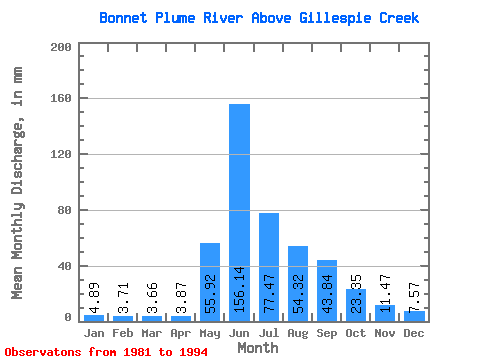
| Units: | m3/s |
| Statistic | Jan | Feb | Mar | Apr | May | Jun | Jul | Aug | Sep | Oct | Nov | Dec | Annual |
|---|---|---|---|---|---|---|---|---|---|---|---|---|---|
| Mean | 4.89 | 3.74 | 3.66 | 3.87 | 55.92 | 156.14 | 77.45 | 54.31 | 43.84 | 23.35 | 11.47 | 7.57 | 444.13 |
| Standard Deviation | 1.17 | 0.76 | 0.56 | 0.91 | 24.16 | 35.93 | 17.43 | 16.85 | 25.16 | 13.46 | 4.53 | 2.09 | 64.31 |
| Min | 3.10 | 2.56 | 2.56 | 2.27 | 21.65 | 117.88 | 47.58 | 31.41 | 19.51 | 9.40 | 6.73 | 5.47 | 346.80 |
| Max | 6.90 | 4.99 | 4.52 | 5.85 | 92.59 | 253.69 | 109.68 | 91.88 | 108.23 | 51.64 | 20.27 | 13.53 | 543.52 |
| Coefficient of Variation | 0.24 | 0.20 | 0.15 | 0.23 | 0.43 | 0.23 | 0.23 | 0.31 | 0.57 | 0.58 | 0.40 | 0.28 | 0.14 |
 Return to R-Arctic Net Home Page