|
|
|||||||||||||||||
| Point ID: 5847 | Downloads | Plots | Site Data | Code: 10MA001 |
|
|
|||||||||||||||||
| Download | |
|---|---|
| Site Descriptor Information | Site Time Series Data |
| Link to all available data | |
| View: | Time Series | All |
| Units: | mm |
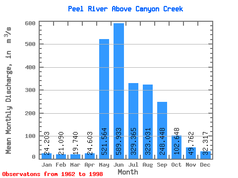
| Statistic | Jan | Feb | Mar | Apr | May | Jun | Jul | Aug | Sep | Oct | Nov | Dec | Annual |
|---|---|---|---|---|---|---|---|---|---|---|---|---|---|
| Mean | 24.20 | 21.09 | 19.74 | 24.60 | 521.56 | 589.93 | 329.37 | 323.03 | 248.45 | 102.65 | 49.76 | 32.32 | 187.20 |
| Standard Deviation | 4.70 | 4.14 | 3.77 | 15.28 | 271.70 | 180.26 | 177.96 | 131.63 | 83.38 | 30.84 | 14.32 | 6.92 | 41.99 |
| Min | 13.00 | 12.80 | 12.30 | 12.60 | 72.90 | 304.00 | 98.30 | 108.00 | 77.80 | 50.60 | 26.10 | 15.70 | 114.28 |
| Max | 32.30 | 29.00 | 26.90 | 93.40 | 1300.00 | 1120.00 | 948.00 | 658.00 | 424.00 | 184.00 | 102.00 | 48.20 | 317.68 |
| Coefficient of Variation | 0.19 | 0.20 | 0.19 | 0.62 | 0.52 | 0.31 | 0.54 | 0.41 | 0.34 | 0.30 | 0.29 | 0.21 | 0.22 |
 Return to R-Arctic Net Home Page