|
|
|||||||||||||||||
| Point ID: 5847 | Downloads | Plots | Site Data | Code: 10MA001 |
|
|
|||||||||||||||||
| Download | |
|---|---|
| Site Descriptor Information | Site Time Series Data |
| Link to all available data | |
| View: | Time Series | All |
| Units: | m3/s |
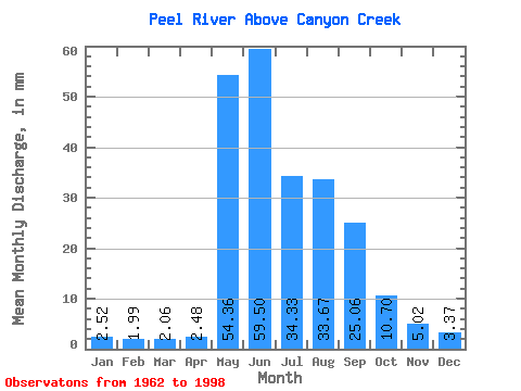
| Statistic | Jan | Feb | Mar | Apr | May | Jun | Jul | Aug | Sep | Oct | Nov | Dec | Annual |
|---|---|---|---|---|---|---|---|---|---|---|---|---|---|
| Mean | 2.52 | 2.00 | 2.06 | 2.48 | 54.35 | 59.50 | 34.32 | 33.66 | 25.06 | 10.70 | 5.02 | 3.37 | 229.89 |
| Standard Deviation | 0.49 | 0.39 | 0.39 | 1.54 | 28.31 | 18.18 | 18.54 | 13.72 | 8.41 | 3.21 | 1.45 | 0.72 | 51.57 |
| Min | 1.35 | 1.22 | 1.28 | 1.27 | 7.60 | 30.66 | 10.24 | 11.25 | 7.85 | 5.27 | 2.63 | 1.64 | 140.34 |
| Max | 3.37 | 2.75 | 2.80 | 9.42 | 135.46 | 112.96 | 98.78 | 68.56 | 42.76 | 19.17 | 10.29 | 5.02 | 390.11 |
| Coefficient of Variation | 0.19 | 0.20 | 0.19 | 0.62 | 0.52 | 0.31 | 0.54 | 0.41 | 0.34 | 0.30 | 0.29 | 0.21 | 0.22 |
 Return to R-Arctic Net Home Page