|
|
|||||||||||||||||
| Point ID: 5841 | Downloads | Plots | Site Data | Code: 10AA004 |
|
|
|||||||||||||||||
| Download | |
|---|---|
| Site Descriptor Information | Site Time Series Data |
| Link to all available data | |
| View: | Time Series | All |
| Units: | mm |
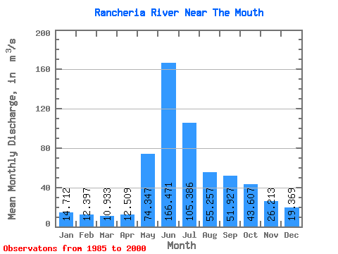
| Statistic | Jan | Feb | Mar | Apr | May | Jun | Jul | Aug | Sep | Oct | Nov | Dec | Annual |
|---|---|---|---|---|---|---|---|---|---|---|---|---|---|
| Mean | 14.71 | 12.40 | 10.93 | 12.51 | 74.35 | 166.47 | 105.39 | 55.26 | 51.93 | 43.61 | 26.21 | 19.37 | 49.50 |
| Standard Deviation | 3.66 | 2.84 | 2.23 | 4.94 | 22.22 | 53.28 | 48.31 | 13.39 | 18.59 | 13.72 | 7.83 | 4.44 | 9.00 |
| Min | 10.00 | 8.02 | 6.85 | 3.43 | 40.60 | 70.60 | 44.30 | 29.60 | 29.80 | 25.00 | 18.60 | 13.90 | 35.88 |
| Max | 21.90 | 18.70 | 15.90 | 27.60 | 114.00 | 251.00 | 240.00 | 85.70 | 92.20 | 69.90 | 46.20 | 28.60 | 68.52 |
| Coefficient of Variation | 0.25 | 0.23 | 0.20 | 0.40 | 0.30 | 0.32 | 0.46 | 0.24 | 0.36 | 0.32 | 0.30 | 0.23 | 0.18 |
 Return to R-Arctic Net Home Page