|
|
|||||||||||||||||
| Point ID: 5841 | Downloads | Plots | Site Data | Code: 10AA004 |
|
|
|||||||||||||||||
| Download | |
|---|---|
| Site Descriptor Information | Site Time Series Data |
| Link to all available data | |
| View: | Time Series | All |
| Units: | m3/s |
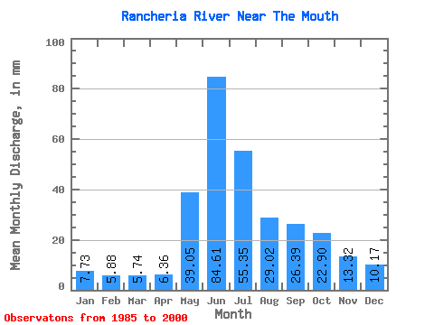
| Statistic | Jan | Feb | Mar | Apr | May | Jun | Jul | Aug | Sep | Oct | Nov | Dec | Annual |
|---|---|---|---|---|---|---|---|---|---|---|---|---|---|
| Mean | 7.73 | 5.93 | 5.74 | 6.36 | 39.04 | 84.61 | 55.34 | 29.02 | 26.39 | 22.90 | 13.32 | 10.17 | 306.33 |
| Standard Deviation | 1.92 | 1.36 | 1.17 | 2.51 | 11.67 | 27.08 | 25.37 | 7.03 | 9.45 | 7.20 | 3.98 | 2.33 | 55.68 |
| Min | 5.25 | 3.84 | 3.60 | 1.74 | 21.32 | 35.88 | 23.26 | 15.54 | 15.14 | 13.13 | 9.45 | 7.30 | 222.06 |
| Max | 11.50 | 8.95 | 8.35 | 14.03 | 59.86 | 127.57 | 126.02 | 45.00 | 46.86 | 36.70 | 23.48 | 15.02 | 424.00 |
| Coefficient of Variation | 0.25 | 0.23 | 0.20 | 0.40 | 0.30 | 0.32 | 0.46 | 0.24 | 0.36 | 0.32 | 0.30 | 0.23 | 0.18 |
 Return to R-Arctic Net Home Page