|
|
|||||||||||||||||
| Point ID: 5826 | Downloads | Plots | Site Data | Code: 09EA005 |
|
|
|||||||||||||||||
| Download | |
|---|---|
| Site Descriptor Information | Site Time Series Data |
| Link to all available data | |
| View: | Time Series | All |
| Units: | mm |
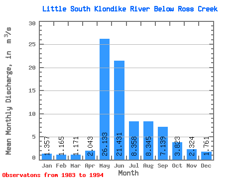
| Statistic | Jan | Feb | Mar | Apr | May | Jun | Jul | Aug | Sep | Oct | Nov | Dec | Annual |
|---|---|---|---|---|---|---|---|---|---|---|---|---|---|
| Mean | 1.36 | 1.17 | 1.17 | 2.04 | 26.13 | 21.43 | 8.36 | 8.35 | 7.14 | 3.82 | 2.32 | 1.76 | 7.02 |
| Standard Deviation | 0.21 | 0.16 | 0.18 | 1.15 | 7.50 | 9.28 | 2.43 | 3.38 | 1.68 | 1.27 | 0.63 | 0.31 | 1.10 |
| Min | 0.84 | 0.88 | 0.83 | 0.90 | 15.40 | 8.47 | 3.90 | 4.37 | 3.83 | 2.40 | 1.57 | 1.35 | 4.85 |
| Max | 1.60 | 1.43 | 1.40 | 5.19 | 41.00 | 35.80 | 12.40 | 14.10 | 9.99 | 7.38 | 4.07 | 2.45 | 8.73 |
| Coefficient of Variation | 0.16 | 0.14 | 0.15 | 0.56 | 0.29 | 0.43 | 0.29 | 0.41 | 0.24 | 0.33 | 0.27 | 0.18 | 0.16 |
 Return to R-Arctic Net Home Page