|
|
|||||||||||||||||
| Point ID: 5826 | Downloads | Plots | Site Data | Code: 09EA005 |
|
|
|||||||||||||||||
| Download | |
|---|---|
| Site Descriptor Information | Site Time Series Data |
| Link to all available data | |
| View: | Time Series | All |
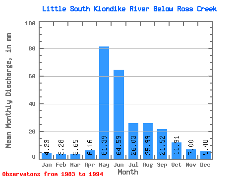
| Units: | m3/s |
| Statistic | Jan | Feb | Mar | Apr | May | Jun | Jul | Aug | Sep | Oct | Nov | Dec | Annual |
|---|---|---|---|---|---|---|---|---|---|---|---|---|---|
| Mean | 4.22 | 3.31 | 3.65 | 6.16 | 81.38 | 64.59 | 26.03 | 25.98 | 21.52 | 11.91 | 7.00 | 5.48 | 257.74 |
| Standard Deviation | 0.66 | 0.45 | 0.56 | 3.47 | 23.36 | 27.98 | 7.56 | 10.52 | 5.07 | 3.96 | 1.90 | 0.98 | 40.57 |
| Min | 2.62 | 2.49 | 2.58 | 2.72 | 47.95 | 25.53 | 12.14 | 13.61 | 11.54 | 7.47 | 4.73 | 4.20 | 177.86 |
| Max | 4.98 | 4.06 | 4.36 | 15.64 | 127.67 | 107.90 | 38.61 | 43.91 | 30.11 | 22.98 | 12.27 | 7.63 | 320.25 |
| Coefficient of Variation | 0.16 | 0.14 | 0.15 | 0.56 | 0.29 | 0.43 | 0.29 | 0.41 | 0.24 | 0.33 | 0.27 | 0.18 | 0.16 |
 Return to R-Arctic Net Home Page