|
|
|||||||||||||||||
| Point ID: 582 | Downloads | Plots | Site Data | Code: 07AA001 |
|
|
|||||||||||||||||
| Download | |
|---|---|
| Site Descriptor Information | Site Time Series Data |
| Link to all available data | |
| View: | Time Series | All |
| Units: | mm |
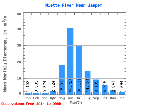
| Statistic | Jan | Feb | Mar | Apr | May | Jun | Jul | Aug | Sep | Oct | Nov | Dec | Annual |
|---|---|---|---|---|---|---|---|---|---|---|---|---|---|
| Mean | 1.10 | 0.90 | 0.87 | 2.32 | 18.01 | 40.72 | 30.11 | 14.42 | 9.20 | 5.92 | 2.85 | 1.69 | 10.69 |
| Standard Deviation | 0.36 | 0.25 | 0.22 | 1.21 | 7.38 | 9.37 | 10.46 | 4.95 | 4.09 | 2.72 | 1.01 | 0.61 | 1.85 |
| Min | 0.51 | 0.49 | 0.51 | 0.64 | 5.16 | 20.30 | 15.00 | 7.17 | 4.89 | 3.13 | 0.96 | 0.78 | 7.55 |
| Max | 2.01 | 1.48 | 1.40 | 4.71 | 33.40 | 55.10 | 61.80 | 26.80 | 25.40 | 16.40 | 5.49 | 3.74 | 14.59 |
| Coefficient of Variation | 0.33 | 0.28 | 0.25 | 0.52 | 0.41 | 0.23 | 0.35 | 0.34 | 0.45 | 0.46 | 0.35 | 0.36 | 0.17 |
 Return to R-Arctic Net Home Page