|
|
|||||||||||||||||
| Point ID: 582 | Downloads | Plots | Site Data | Code: 07AA001 |
|
|
|||||||||||||||||
| Download | |
|---|---|
| Site Descriptor Information | Site Time Series Data |
| Link to all available data | |
| View: | Time Series | All |
| Units: | m3/s |
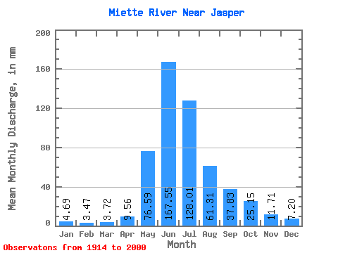
| Statistic | Jan | Feb | Mar | Apr | May | Jun | Jul | Aug | Sep | Oct | Nov | Dec | Annual |
|---|---|---|---|---|---|---|---|---|---|---|---|---|---|
| Mean | 4.68 | 3.50 | 3.71 | 9.56 | 76.57 | 167.55 | 128.00 | 61.30 | 37.83 | 25.14 | 11.71 | 7.20 | 535.65 |
| Standard Deviation | 1.53 | 0.98 | 0.93 | 4.97 | 31.36 | 38.54 | 44.46 | 21.04 | 16.85 | 11.58 | 4.15 | 2.61 | 92.66 |
| Min | 2.18 | 1.90 | 2.16 | 2.63 | 21.93 | 83.52 | 63.76 | 30.48 | 20.12 | 13.30 | 3.96 | 3.30 | 378.35 |
| Max | 8.54 | 5.73 | 5.95 | 19.38 | 141.98 | 226.70 | 262.70 | 113.92 | 104.50 | 69.71 | 22.59 | 15.90 | 730.87 |
| Coefficient of Variation | 0.33 | 0.28 | 0.25 | 0.52 | 0.41 | 0.23 | 0.35 | 0.34 | 0.45 | 0.46 | 0.35 | 0.36 | 0.17 |
 Return to R-Arctic Net Home Page