|
|
|||||||||||||||||
| Point ID: 5803 | Downloads | Plots | Site Data | Code: 09BA002 |
|
|
|||||||||||||||||
| Download | |
|---|---|
| Site Descriptor Information | Site Time Series Data |
| Link to all available data | |
| View: | Time Series | All |
| Units: | mm |
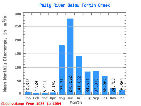
| Statistic | Jan | Feb | Mar | Apr | May | Jun | Jul | Aug | Sep | Oct | Nov | Dec | Annual |
|---|---|---|---|---|---|---|---|---|---|---|---|---|---|
| Mean | 10.31 | 7.52 | 6.41 | 8.14 | 179.71 | 278.22 | 141.82 | 84.51 | 87.38 | 68.07 | 24.72 | 16.86 | 76.14 |
| Standard Deviation | 4.07 | 2.67 | 2.35 | 2.94 | 63.54 | 69.89 | 48.93 | 44.51 | 46.40 | 23.90 | 7.32 | 4.36 | 14.72 |
| Min | 1.82 | 1.36 | 1.07 | 1.20 | 86.40 | 175.00 | 62.00 | 32.00 | 21.70 | 24.30 | 13.20 | 9.24 | 47.56 |
| Max | 16.10 | 10.60 | 9.15 | 11.40 | 260.00 | 418.00 | 208.00 | 181.00 | 168.00 | 103.00 | 34.40 | 23.80 | 102.39 |
| Coefficient of Variation | 0.39 | 0.35 | 0.37 | 0.36 | 0.35 | 0.25 | 0.34 | 0.53 | 0.53 | 0.35 | 0.30 | 0.26 | 0.19 |
 Return to R-Arctic Net Home Page