|
|
|||||||||||||||||
| Point ID: 5803 | Downloads | Plots | Site Data | Code: 09BA002 |
|
|
|||||||||||||||||
| Download | |
|---|---|
| Site Descriptor Information | Site Time Series Data |
| Link to all available data | |
| View: | Time Series | All |
| Units: | m3/s |
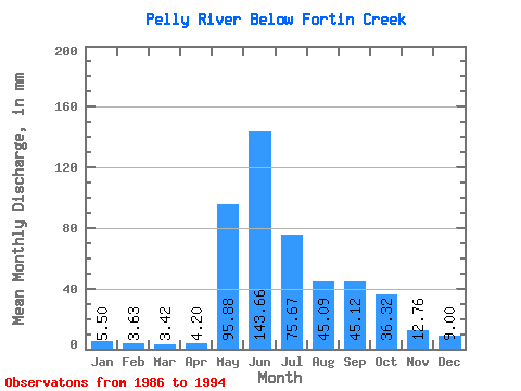
| Statistic | Jan | Feb | Mar | Apr | May | Jun | Jul | Aug | Sep | Oct | Nov | Dec | Annual |
|---|---|---|---|---|---|---|---|---|---|---|---|---|---|
| Mean | 5.50 | 3.66 | 3.42 | 4.21 | 95.87 | 143.66 | 75.66 | 45.08 | 45.12 | 36.31 | 12.77 | 8.99 | 478.68 |
| Standard Deviation | 2.17 | 1.30 | 1.25 | 1.52 | 33.90 | 36.09 | 26.10 | 23.75 | 23.96 | 12.75 | 3.78 | 2.32 | 92.55 |
| Min | 0.97 | 0.66 | 0.57 | 0.62 | 46.09 | 90.36 | 33.08 | 17.07 | 11.20 | 12.96 | 6.82 | 4.93 | 299.03 |
| Max | 8.59 | 5.15 | 4.88 | 5.89 | 138.70 | 215.83 | 110.96 | 96.56 | 86.74 | 54.95 | 17.76 | 12.70 | 643.74 |
| Coefficient of Variation | 0.39 | 0.35 | 0.37 | 0.36 | 0.35 | 0.25 | 0.34 | 0.53 | 0.53 | 0.35 | 0.30 | 0.26 | 0.19 |
 Return to R-Arctic Net Home Page