|
|
|||||||||||||||||
| Point ID: 5794 | Downloads | Plots | Site Data | Code: 09AD002 |
|
|
|||||||||||||||||
| Download | |
|---|---|
| Site Descriptor Information | Site Time Series Data |
| Link to all available data | |
| View: | Time Series | All |
| Units: | mm |
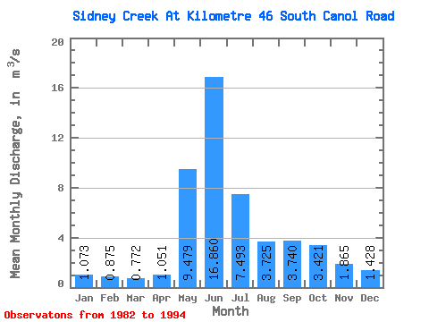
| Statistic | Jan | Feb | Mar | Apr | May | Jun | Jul | Aug | Sep | Oct | Nov | Dec | Annual |
|---|---|---|---|---|---|---|---|---|---|---|---|---|---|
| Mean | 1.07 | 0.88 | 0.77 | 1.05 | 9.48 | 16.86 | 7.49 | 3.73 | 3.74 | 3.42 | 1.86 | 1.43 | 4.29 |
| Standard Deviation | 0.23 | 0.18 | 0.21 | 0.52 | 3.78 | 5.02 | 3.38 | 1.13 | 1.67 | 1.47 | 0.71 | 0.40 | 0.93 |
| Min | 0.71 | 0.47 | 0.42 | 0.40 | 2.14 | 7.12 | 2.92 | 2.26 | 2.25 | 1.64 | 1.06 | 0.90 | 2.99 |
| Max | 1.52 | 1.15 | 1.17 | 2.07 | 14.60 | 28.00 | 13.70 | 5.84 | 8.87 | 5.98 | 3.23 | 2.17 | 5.98 |
| Coefficient of Variation | 0.21 | 0.20 | 0.27 | 0.50 | 0.40 | 0.30 | 0.45 | 0.30 | 0.45 | 0.43 | 0.38 | 0.28 | 0.22 |
 Return to R-Arctic Net Home Page