|
|
|||||||||||||||||
| Point ID: 5794 | Downloads | Plots | Site Data | Code: 09AD002 |
|
|
|||||||||||||||||
| Download | |
|---|---|
| Site Descriptor Information | Site Time Series Data |
| Link to all available data | |
| View: | Time Series | All |
| Units: | m3/s |
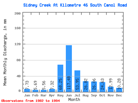
| Statistic | Jan | Feb | Mar | Apr | May | Jun | Jul | Aug | Sep | Oct | Nov | Dec | Annual |
|---|---|---|---|---|---|---|---|---|---|---|---|---|---|
| Mean | 7.72 | 5.74 | 5.56 | 7.32 | 68.24 | 117.48 | 53.94 | 26.82 | 26.06 | 24.63 | 13.00 | 10.28 | 363.77 |
| Standard Deviation | 1.65 | 1.15 | 1.51 | 3.63 | 27.24 | 34.98 | 24.30 | 8.14 | 11.64 | 10.59 | 4.95 | 2.84 | 79.01 |
| Min | 5.13 | 3.11 | 3.04 | 2.80 | 15.41 | 49.61 | 21.02 | 16.27 | 15.68 | 11.81 | 7.39 | 6.49 | 253.87 |
| Max | 10.94 | 7.54 | 8.42 | 14.42 | 105.10 | 195.10 | 98.62 | 42.04 | 61.80 | 43.05 | 22.51 | 15.62 | 507.69 |
| Coefficient of Variation | 0.21 | 0.20 | 0.27 | 0.50 | 0.40 | 0.30 | 0.45 | 0.30 | 0.45 | 0.43 | 0.38 | 0.28 | 0.22 |
 Return to R-Arctic Net Home Page