|
|
|||||||||||||||||
| Point ID: 571 | Downloads | Plots | Site Data | Code: 06AB001 |
|
|
|||||||||||||||||
| Download | |
|---|---|
| Site Descriptor Information | Site Time Series Data |
| Link to all available data | |
| View: | Time Series | All |
| Units: | mm |
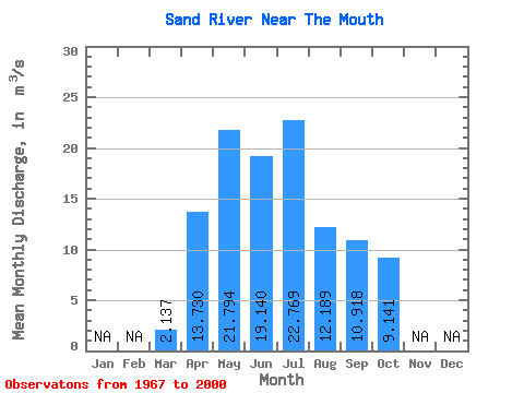
| Statistic | Jan | Feb | Mar | Apr | May | Jun | Jul | Aug | Sep | Oct | Nov | Dec | Annual |
|---|---|---|---|---|---|---|---|---|---|---|---|---|---|
| Mean | 2.14 | 13.73 | 21.79 | 19.14 | 22.77 | 12.19 | 10.92 | 9.14 | |||||
| Standard Deviation | 0.93 | 11.60 | 24.30 | 23.64 | 26.78 | 10.58 | 11.25 | 9.00 | |||||
| Min | 0.52 | 3.73 | 2.97 | 1.14 | 1.35 | 0.72 | 0.80 | 0.69 | |||||
| Max | 4.36 | 56.40 | 127.00 | 131.00 | 101.00 | 42.00 | 40.20 | 33.30 | |||||
| Coefficient of Variation | 0.44 | 0.84 | 1.11 | 1.23 | 1.18 | 0.87 | 1.03 | 0.98 |
 Return to R-Arctic Net Home Page