|
|
|||||||||||||||||
| Point ID: 571 | Downloads | Plots | Site Data | Code: 06AB001 |
|
|
|||||||||||||||||
| Download | |
|---|---|
| Site Descriptor Information | Site Time Series Data |
| Link to all available data | |
| View: | Time Series | All |
| Units: | m3/s |
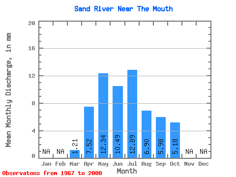
| Statistic | Jan | Feb | Mar | Apr | May | Jun | Jul | Aug | Sep | Oct | Nov | Dec | Annual |
|---|---|---|---|---|---|---|---|---|---|---|---|---|---|
| Mean | 1.17 | 7.25 | 11.89 | 10.10 | 12.42 | 6.65 | 5.76 | 4.99 | |||||
| Standard Deviation | 0.51 | 6.12 | 13.25 | 12.48 | 14.61 | 5.77 | 5.94 | 4.91 | |||||
| Min | 0.28 | 1.97 | 1.62 | 0.60 | 0.74 | 0.40 | 0.42 | 0.38 | |||||
| Max | 2.38 | 29.77 | 69.27 | 69.16 | 55.09 | 22.91 | 21.22 | 18.16 | |||||
| Coefficient of Variation | 0.44 | 0.84 | 1.11 | 1.23 | 1.18 | 0.87 | 1.03 | 0.98 |
 Return to R-Arctic Net Home Page