|
|
|||||||||||||||||
| Point ID: 5623 | Downloads | Plots | Site Data | Code: 07QC001 |
|
|
|||||||||||||||||
| Download | |
|---|---|
| Site Descriptor Information | Site Time Series Data |
| Link to all available data | |
| View: | Time Series | All |
| Units: | mm |
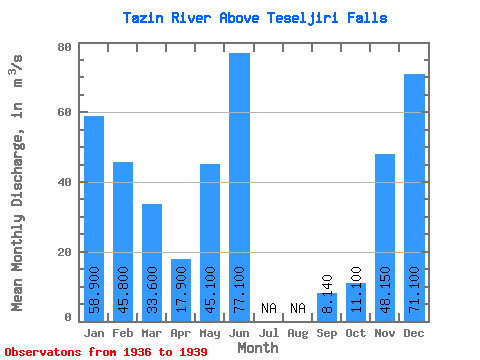
| Statistic | Jan | Feb | Mar | Apr | May | Jun | Jul | Aug | Sep | Oct | Nov | Dec | Annual |
|---|---|---|---|---|---|---|---|---|---|---|---|---|---|
| Mean | 58.90 | 45.80 | 33.60 | 17.90 | 45.10 | 77.10 | 8.14 | 11.10 | 48.15 | 71.10 | |||
| Standard Deviation | 50.42 | ||||||||||||
| Min | 58.90 | 45.80 | 33.60 | 17.90 | 45.10 | 77.10 | 8.14 | 11.10 | 12.50 | 71.10 | |||
| Max | 58.90 | 45.80 | 33.60 | 17.90 | 45.10 | 77.10 | 8.14 | 11.10 | 83.80 | 71.10 | |||
| Coefficient of Variation | 1.05 |
 Return to R-Arctic Net Home Page