|
|
|||||||||||||||||
| Point ID: 5623 | Downloads | Plots | Site Data | Code: 07QC001 |
|
|
|||||||||||||||||
| Download | |
|---|---|
| Site Descriptor Information | Site Time Series Data |
| Link to all available data | |
| View: | Time Series | All |
| Units: | m3/s |
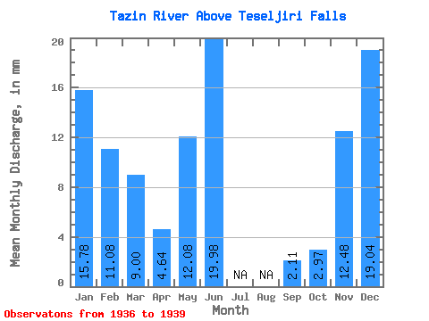
| Statistic | Jan | Feb | Mar | Apr | May | Jun | Jul | Aug | Sep | Oct | Nov | Dec | Annual |
|---|---|---|---|---|---|---|---|---|---|---|---|---|---|
| Mean | 15.77 | 11.18 | 9.00 | 4.64 | 12.08 | 19.98 | 2.11 | 2.97 | 12.48 | 19.04 | |||
| Standard Deviation | 13.07 | ||||||||||||
| Min | 15.77 | 11.18 | 9.00 | 4.64 | 12.08 | 19.98 | 2.11 | 2.97 | 3.24 | 19.04 | |||
| Max | 15.77 | 11.18 | 9.00 | 4.64 | 12.08 | 19.98 | 2.11 | 2.97 | 21.72 | 19.04 | |||
| Coefficient of Variation | 1.05 |
 Return to R-Arctic Net Home Page