|
|
|||||||||||||||||
| Point ID: 5615 | Downloads | Plots | Site Data | Other Close Sites | Code: 07LE002 |
|
|
|||||||||||||||||
| Download | |
|---|---|
| Site Descriptor Information | Site Time Series Data |
| Link to all available data | |
| View: | Time Series | All |
| Units: | mm |
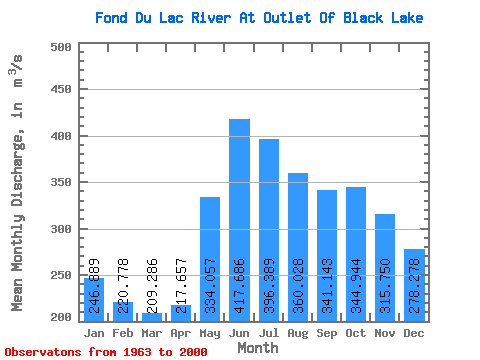
| Statistic | Jan | Feb | Mar | Apr | May | Jun | Jul | Aug | Sep | Oct | Nov | Dec | Annual |
|---|---|---|---|---|---|---|---|---|---|---|---|---|---|
| Mean | 246.89 | 220.78 | 209.29 | 217.66 | 334.06 | 417.69 | 396.39 | 360.03 | 341.14 | 344.94 | 315.75 | 278.28 | 305.79 |
| Standard Deviation | 48.88 | 43.76 | 40.98 | 42.57 | 66.01 | 88.24 | 84.21 | 75.88 | 79.60 | 109.20 | 85.63 | 60.23 | 49.26 |
| Min | 162.00 | 133.00 | 125.00 | 128.00 | 201.00 | 275.00 | 252.00 | 232.00 | 226.00 | 208.00 | 187.00 | 174.00 | 231.83 |
| Max | 416.00 | 371.00 | 352.00 | 359.00 | 485.00 | 600.00 | 630.00 | 607.00 | 584.00 | 786.00 | 604.00 | 476.00 | 445.17 |
| Coefficient of Variation | 0.20 | 0.20 | 0.20 | 0.20 | 0.20 | 0.21 | 0.21 | 0.21 | 0.23 | 0.32 | 0.27 | 0.22 | 0.16 |
| Other Close Sites | ||||||
|---|---|---|---|---|---|---|
| PointID | Latitude | Longitude | Drainage Area | Source | Name | |
| 5614 | "FOND DU LAC RIVER AT STONY RAPIDS" | 59.26 | 919600 | Hydat | ||
 Return to R-Arctic Net Home Page