|
|
|||||||||||||||||
| Point ID: 5614 | Downloads | Plots | Site Data | Other Close Sites | Code: 07LE001 |
|
|
|||||||||||||||||
| Download | |
|---|---|
| Site Descriptor Information | Site Time Series Data |
| Link to all available data | |
| View: | Time Series | All |
| Units: | mm |
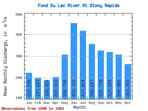
| Statistic | Jan | Feb | Mar | Apr | May | Jun | Jul | Aug | Sep | Oct | Nov | Dec | Annual |
|---|---|---|---|---|---|---|---|---|---|---|---|---|---|
| Mean | 222.29 | 197.65 | 188.82 | 202.41 | 306.71 | 453.76 | 417.82 | 355.65 | 325.78 | 319.06 | 306.88 | 263.35 | 298.75 |
| Standard Deviation | 57.39 | 51.52 | 34.24 | 26.89 | 60.85 | 124.74 | 124.96 | 86.57 | 81.06 | 92.78 | 93.42 | 67.83 | 63.26 |
| Min | 145.00 | 132.00 | 138.00 | 173.00 | 195.00 | 255.00 | 240.00 | 215.00 | 208.00 | 202.00 | 195.00 | 171.00 | 210.25 |
| Max | 367.00 | 336.00 | 277.00 | 259.00 | 398.00 | 681.00 | 760.00 | 553.00 | 476.00 | 455.00 | 514.00 | 400.00 | 406.42 |
| Coefficient of Variation | 0.26 | 0.26 | 0.18 | 0.13 | 0.20 | 0.28 | 0.30 | 0.24 | 0.25 | 0.29 | 0.30 | 0.26 | 0.21 |
| Other Close Sites | ||||||
|---|---|---|---|---|---|---|
| PointID | Latitude | Longitude | Drainage Area | Source | Name | |
| 5615 | "FOND DU LAC RIVER AT OUTLET OF BLACK LAKE" | 59.14 | 907720 | Hydat | ||
 Return to R-Arctic Net Home Page