|
|
|||||||||||||||||
| Point ID: 5613 | Downloads | Plots | Site Data | Code: 07LD003 |
|
|
|||||||||||||||||
| Download | |
|---|---|
| Site Descriptor Information | Site Time Series Data |
| Link to all available data | |
| View: | Time Series | All |
| Units: | mm |
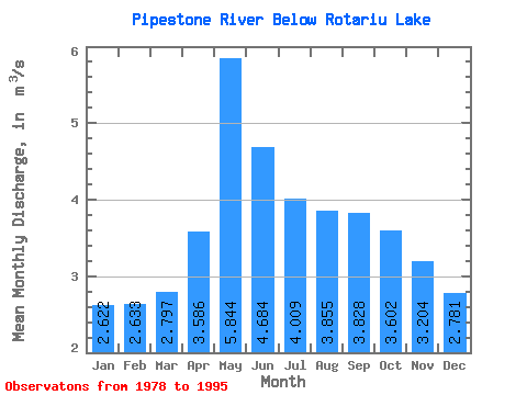
| Statistic | Jan | Feb | Mar | Apr | May | Jun | Jul | Aug | Sep | Oct | Nov | Dec | Annual |
|---|---|---|---|---|---|---|---|---|---|---|---|---|---|
| Mean | 2.62 | 2.63 | 2.80 | 3.59 | 5.84 | 4.68 | 4.01 | 3.85 | 3.83 | 3.60 | 3.20 | 2.78 | 3.59 |
| Standard Deviation | 0.62 | 0.64 | 0.62 | 0.88 | 1.53 | 1.13 | 0.94 | 1.17 | 0.97 | 1.00 | 0.80 | 0.68 | 0.55 |
| Min | 1.28 | 1.33 | 1.18 | 1.62 | 3.76 | 2.90 | 1.92 | 2.05 | 1.84 | 1.74 | 1.81 | 1.72 | 2.64 |
| Max | 3.55 | 3.64 | 3.63 | 4.94 | 9.45 | 7.72 | 5.43 | 7.00 | 5.18 | 6.29 | 5.03 | 4.00 | 4.51 |
| Coefficient of Variation | 0.24 | 0.24 | 0.22 | 0.25 | 0.26 | 0.24 | 0.23 | 0.30 | 0.25 | 0.28 | 0.25 | 0.24 | 0.15 |
 Return to R-Arctic Net Home Page