|
|
|||||||||||||||||
| Point ID: 5613 | Downloads | Plots | Site Data | Code: 07LD003 |
|
|
|||||||||||||||||
| Download | |
|---|---|
| Site Descriptor Information | Site Time Series Data |
| Link to all available data | |
| View: | Time Series | All |
| Units: | m3/s |
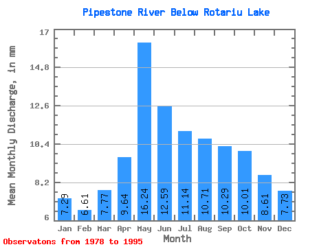
| Statistic | Jan | Feb | Mar | Apr | May | Jun | Jul | Aug | Sep | Oct | Nov | Dec | Annual |
|---|---|---|---|---|---|---|---|---|---|---|---|---|---|
| Mean | 7.29 | 6.66 | 7.77 | 9.64 | 16.24 | 12.59 | 11.14 | 10.71 | 10.29 | 10.01 | 8.62 | 7.73 | 117.47 |
| Standard Deviation | 1.73 | 1.63 | 1.72 | 2.38 | 4.24 | 3.04 | 2.60 | 3.26 | 2.62 | 2.79 | 2.14 | 1.89 | 18.11 |
| Min | 3.56 | 3.37 | 3.28 | 4.36 | 10.45 | 7.80 | 5.33 | 5.70 | 4.95 | 4.83 | 4.87 | 4.78 | 86.29 |
| Max | 9.86 | 9.21 | 10.08 | 13.28 | 26.25 | 20.76 | 15.09 | 19.45 | 13.93 | 17.47 | 13.53 | 11.11 | 147.60 |
| Coefficient of Variation | 0.24 | 0.24 | 0.22 | 0.25 | 0.26 | 0.24 | 0.23 | 0.30 | 0.25 | 0.28 | 0.25 | 0.24 | 0.15 |
 Return to R-Arctic Net Home Page