|
|
|||||||||||||||||
| Point ID: 5590 | Downloads | Plots | Site Data | Code: 06CC001 |
|
|
|||||||||||||||||
| Download | |
|---|---|
| Site Descriptor Information | Site Time Series Data |
| Link to all available data | |
| View: | Time Series | All |
| Units: | mm |
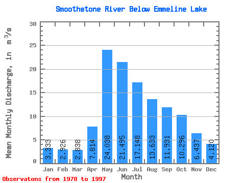
| Statistic | Jan | Feb | Mar | Apr | May | Jun | Jul | Aug | Sep | Oct | Nov | Dec | Annual |
|---|---|---|---|---|---|---|---|---|---|---|---|---|---|
| Mean | 3.33 | 2.93 | 2.84 | 7.81 | 24.04 | 21.50 | 17.15 | 13.63 | 11.93 | 10.30 | 6.44 | 4.12 | 10.04 |
| Standard Deviation | 1.41 | 1.25 | 1.24 | 5.82 | 13.58 | 10.86 | 10.04 | 8.33 | 9.20 | 8.67 | 3.44 | 1.56 | 3.02 |
| Min | 1.40 | 0.92 | 1.07 | 1.86 | 1.62 | 0.88 | 5.39 | 5.11 | 4.41 | 3.75 | 2.78 | 2.22 | 3.44 |
| Max | 6.33 | 5.77 | 4.89 | 23.80 | 56.70 | 41.10 | 38.70 | 40.00 | 41.60 | 39.50 | 16.90 | 8.04 | 15.78 |
| Coefficient of Variation | 0.42 | 0.43 | 0.44 | 0.74 | 0.56 | 0.51 | 0.59 | 0.61 | 0.77 | 0.84 | 0.53 | 0.38 | 0.30 |
 Return to R-Arctic Net Home Page