|
|
|||||||||||||||||
| Point ID: 5590 | Downloads | Plots | Site Data | Code: 06CC001 |
|
|
|||||||||||||||||
| Download | |
|---|---|
| Site Descriptor Information | Site Time Series Data |
| Link to all available data | |
| View: | Time Series | All |
| Units: | m3/s |
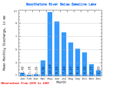
| Statistic | Jan | Feb | Mar | Apr | May | Jun | Jul | Aug | Sep | Oct | Nov | Dec | Annual |
|---|---|---|---|---|---|---|---|---|---|---|---|---|---|
| Mean | 1.48 | 1.19 | 1.26 | 3.37 | 10.69 | 9.26 | 7.63 | 6.07 | 5.14 | 4.58 | 2.77 | 1.83 | 52.66 |
| Standard Deviation | 0.63 | 0.51 | 0.55 | 2.50 | 6.04 | 4.68 | 4.47 | 3.71 | 3.96 | 3.86 | 1.48 | 0.69 | 15.84 |
| Min | 0.62 | 0.37 | 0.48 | 0.80 | 0.72 | 0.38 | 2.40 | 2.27 | 1.90 | 1.67 | 1.20 | 0.99 | 18.03 |
| Max | 2.82 | 2.34 | 2.17 | 10.25 | 25.22 | 17.70 | 17.22 | 17.79 | 17.91 | 17.57 | 7.28 | 3.58 | 82.71 |
| Coefficient of Variation | 0.42 | 0.43 | 0.44 | 0.74 | 0.56 | 0.51 | 0.59 | 0.61 | 0.77 | 0.84 | 0.53 | 0.38 | 0.30 |
 Return to R-Arctic Net Home Page