|
|
|||||||||||||||||
| Point ID: 5588 | Downloads | Plots | Site Data | Code: 06CA009 |
|
|
|||||||||||||||||
| Download | |
|---|---|
| Site Descriptor Information | Site Time Series Data |
| Link to all available data | |
| View: | Time Series | All |
| Units: | mm |
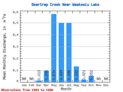
| Statistic | Jan | Feb | Mar | Apr | May | Jun | Jul | Aug | Sep | Oct | Nov | Dec | Annual |
|---|---|---|---|---|---|---|---|---|---|---|---|---|---|
| Mean | 0.01 | 0.10 | 0.57 | 0.50 | 0.50 | 0.13 | 0.02 | 0.05 | |||||
| Standard Deviation | 0.01 | 0.10 | 0.58 | 0.60 | 0.43 | 0.10 | 0.01 | 0.06 | |||||
| Min | 0.00 | 0.04 | 0.00 | 0.01 | 0.05 | 0.02 | 0.00 | 0.00 | |||||
| Max | 0.02 | 0.27 | 1.56 | 1.49 | 1.01 | 0.24 | 0.04 | 0.14 | |||||
| Coefficient of Variation | 0.88 | 1.02 | 1.02 | 1.20 | 0.87 | 0.75 | 0.71 | 1.08 |
 Return to R-Arctic Net Home Page