|
|
| Point ID: 5588 | Downloads | Plots | Site Data | Code: 06CA009 |
|
| Download | |
|---|---|
| Site Descriptor Information | Site Time Series Data |
| Link to all available data | |
|
|
|
| View: | Statistics | All |
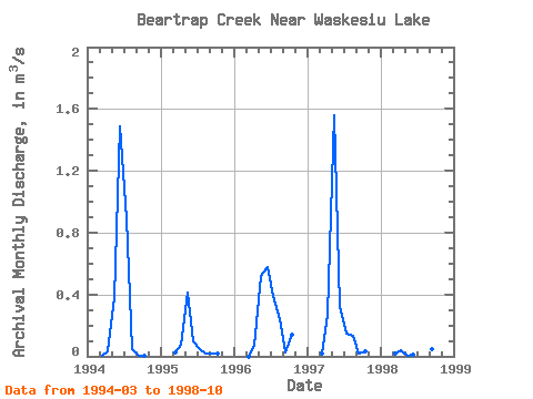
| Units: | mm |
| Year | Jan | Feb | Mar | Apr | May | Jun | Jul | Aug | Sep | Oct | Nov | Dec | Annual | 1994 | 0.00 | 0.04 | 0.38 | 1.49 | 0.89 | 0.05 | 0.00 | 0.00 | 1995 | 0.02 | 0.07 | 0.41 | 0.10 | 0.05 | 0.02 | 0.02 | 0.02 | 1996 | 0.00 | 0.07 | 0.52 | 0.58 | 0.39 | 0.24 | 0.02 | 0.14 | 1997 | 0.02 | 0.27 | 1.56 | 0.32 | 0.15 | 0.14 | 0.02 | 0.03 | 1998 | 0.02 | 0.04 | 0.00 | 0.01 | 1.01 | 0.22 | 0.04 | 0.07 |
|---|
 Return to R-Arctic Net Home Page