|
|
|||||||||||||||||
| Point ID: 5584 | Downloads | Plots | Site Data | Code: 06BC001 |
|
|
|||||||||||||||||
| Download | |
|---|---|
| Site Descriptor Information | Site Time Series Data |
| Link to all available data | |
| View: | Time Series | All |
| Units: | mm |
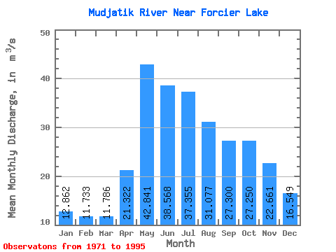
| Statistic | Jan | Feb | Mar | Apr | May | Jun | Jul | Aug | Sep | Oct | Nov | Dec | Annual |
|---|---|---|---|---|---|---|---|---|---|---|---|---|---|
| Mean | 12.86 | 11.73 | 11.79 | 21.32 | 42.84 | 38.57 | 37.35 | 31.08 | 27.30 | 27.25 | 22.66 | 16.55 | 25.18 |
| Standard Deviation | 2.31 | 2.18 | 2.42 | 6.31 | 11.77 | 13.13 | 19.34 | 16.11 | 13.95 | 9.88 | 7.41 | 4.20 | 5.40 |
| Min | 7.00 | 6.23 | 5.71 | 11.10 | 23.70 | 18.00 | 16.60 | 12.90 | 10.40 | 11.30 | 10.40 | 9.61 | 16.13 |
| Max | 17.40 | 15.40 | 15.60 | 36.90 | 68.50 | 68.10 | 85.70 | 67.20 | 73.60 | 45.50 | 36.10 | 27.20 | 36.19 |
| Coefficient of Variation | 0.18 | 0.19 | 0.21 | 0.30 | 0.28 | 0.34 | 0.52 | 0.52 | 0.51 | 0.36 | 0.33 | 0.25 | 0.21 |
 Return to R-Arctic Net Home Page