|
|
|||||||||||||||||
| Point ID: 5584 | Downloads | Plots | Site Data | Code: 06BC001 |
|
|
|||||||||||||||||
| Download | |
|---|---|
| Site Descriptor Information | Site Time Series Data |
| Link to all available data | |
| View: | Time Series | All |
| Units: | m3/s |
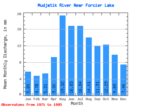
| Statistic | Jan | Feb | Mar | Apr | May | Jun | Jul | Aug | Sep | Oct | Nov | Dec | Annual |
|---|---|---|---|---|---|---|---|---|---|---|---|---|---|
| Mean | 5.80 | 4.82 | 5.31 | 9.30 | 19.31 | 16.83 | 16.84 | 14.01 | 11.91 | 12.29 | 9.89 | 7.46 | 133.80 |
| Standard Deviation | 1.04 | 0.90 | 1.09 | 2.75 | 5.31 | 5.73 | 8.72 | 7.26 | 6.09 | 4.45 | 3.23 | 1.89 | 28.70 |
| Min | 3.16 | 2.56 | 2.57 | 4.84 | 10.69 | 7.86 | 7.48 | 5.82 | 4.54 | 5.09 | 4.54 | 4.33 | 85.72 |
| Max | 7.84 | 6.33 | 7.03 | 16.10 | 30.88 | 29.72 | 38.64 | 30.30 | 32.12 | 20.51 | 15.75 | 12.26 | 192.29 |
| Coefficient of Variation | 0.18 | 0.19 | 0.21 | 0.30 | 0.28 | 0.34 | 0.52 | 0.52 | 0.51 | 0.36 | 0.33 | 0.25 | 0.21 |
 Return to R-Arctic Net Home Page