|
|
|||||||||||||||||
| Point ID: 5568 | Downloads | Plots | Site Data | Code: 06AD007 |
|
|
|||||||||||||||||
| Download | |
|---|---|
| Site Descriptor Information | Site Time Series Data |
| Link to all available data | |
| View: | Time Series | All |
| Units: | mm |
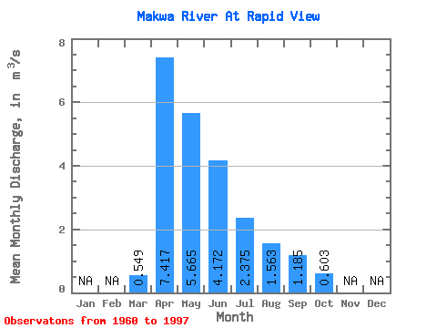
| Statistic | Jan | Feb | Mar | Apr | May | Jun | Jul | Aug | Sep | Oct | Nov | Dec | Annual |
|---|---|---|---|---|---|---|---|---|---|---|---|---|---|
| Mean | 0.55 | 7.42 | 5.67 | 4.17 | 2.38 | 1.56 | 1.19 | 0.60 | |||||
| Standard Deviation | 0.57 | 5.70 | 5.52 | 5.70 | 3.58 | 2.48 | 2.19 | 0.59 | |||||
| Min | 0.00 | 0.21 | 0.01 | 0.00 | 0.00 | 0.00 | 0.00 | 0.00 | |||||
| Max | 2.10 | 29.30 | 23.60 | 26.30 | 14.50 | 10.90 | 9.43 | 1.97 | |||||
| Coefficient of Variation | 1.03 | 0.77 | 0.97 | 1.37 | 1.51 | 1.59 | 1.85 | 0.98 |
 Return to R-Arctic Net Home Page