|
|
|||||||||||||||||
| Point ID: 5568 | Downloads | Plots | Site Data | Code: 06AD007 |
|
|
|||||||||||||||||
| Download | |
|---|---|
| Site Descriptor Information | Site Time Series Data |
| Link to all available data | |
| View: | Time Series | All |
| Units: | m3/s |
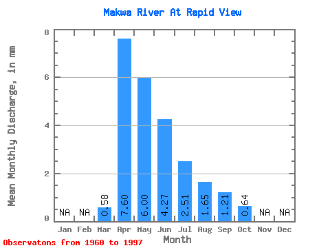
| Statistic | Jan | Feb | Mar | Apr | May | Jun | Jul | Aug | Sep | Oct | Nov | Dec | Annual |
|---|---|---|---|---|---|---|---|---|---|---|---|---|---|
| Mean | 0.54 | 7.02 | 5.54 | 3.95 | 2.32 | 1.53 | 1.12 | 0.59 | |||||
| Standard Deviation | 0.55 | 5.39 | 5.40 | 5.39 | 3.50 | 2.43 | 2.07 | 0.57 | |||||
| Min | 0.00 | 0.20 | 0.01 | 0.00 | 0.00 | 0.00 | 0.00 | 0.00 | |||||
| Max | 2.05 | 27.72 | 23.07 | 24.88 | 14.17 | 10.65 | 8.92 | 1.93 | |||||
| Coefficient of Variation | 1.03 | 0.77 | 0.97 | 1.37 | 1.51 | 1.59 | 1.85 | 0.98 |
 Return to R-Arctic Net Home Page