|
|
|||||||||||||||||
| Point ID: 5567 | Downloads | Plots | Site Data | Code: 06AD005 |
|
|
|||||||||||||||||
| Download | |
|---|---|
| Site Descriptor Information | Site Time Series Data |
| Link to all available data | |
| View: | Time Series | All |
| Units: | mm |
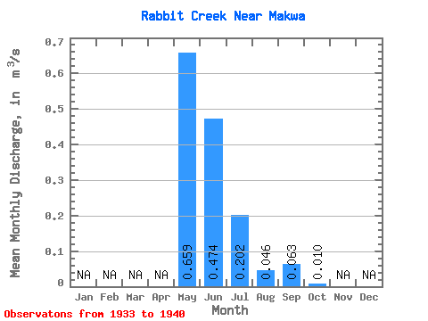
| Statistic | Jan | Feb | Mar | Apr | May | Jun | Jul | Aug | Sep | Oct | Nov | Dec | Annual |
|---|---|---|---|---|---|---|---|---|---|---|---|---|---|
| Mean | 0.66 | 0.47 | 0.20 | 0.05 | 0.06 | 0.01 | |||||||
| Standard Deviation | 0.76 | 0.84 | 0.28 | 0.07 | 0.16 | 0.02 | |||||||
| Min | 0.01 | 0.01 | 0.00 | 0.00 | 0.00 | 0.00 | |||||||
| Max | 2.31 | 2.51 | 0.72 | 0.17 | 0.42 | 0.04 | |||||||
| Coefficient of Variation | 1.16 | 1.77 | 1.37 | 1.44 | 2.53 | 1.65 |
 Return to R-Arctic Net Home Page