|
|
|||||||||||||||||
| Point ID: 5567 | Downloads | Plots | Site Data | Code: 06AD005 |
|
|
|||||||||||||||||
| Download | |
|---|---|
| Site Descriptor Information | Site Time Series Data |
| Link to all available data | |
| View: | Time Series | All |
| Units: | m3/s |
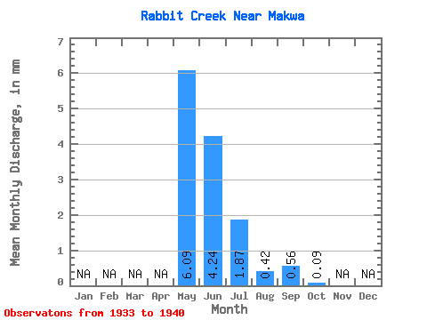
| Statistic | Jan | Feb | Mar | Apr | May | Jun | Jul | Aug | Sep | Oct | Nov | Dec | Annual |
|---|---|---|---|---|---|---|---|---|---|---|---|---|---|
| Mean | 6.09 | 4.24 | 1.87 | 0.43 | 0.56 | 0.09 | |||||||
| Standard Deviation | 7.05 | 7.48 | 2.57 | 0.61 | 1.42 | 0.15 | |||||||
| Min | 0.07 | 0.11 | 0.01 | 0.00 | 0.00 | 0.00 | |||||||
| Max | 21.33 | 22.43 | 6.61 | 1.58 | 3.78 | 0.39 | |||||||
| Coefficient of Variation | 1.16 | 1.77 | 1.37 | 1.44 | 2.53 | 1.65 |
 Return to R-Arctic Net Home Page