|
|
|||||||||||||||||
| Point ID: 5559 | Downloads | Plots | Site Data | Code: 05NE003 |
|
|
|||||||||||||||||
| Download | |
|---|---|
| Site Descriptor Information | Site Time Series Data |
| Link to all available data | |
| View: | Time Series | All |
| Units: | mm |
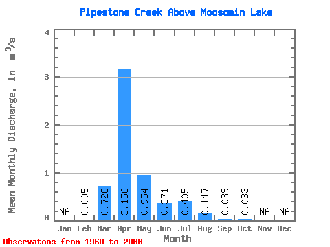
| Statistic | Jan | Feb | Mar | Apr | May | Jun | Jul | Aug | Sep | Oct | Nov | Dec | Annual |
|---|---|---|---|---|---|---|---|---|---|---|---|---|---|
| Mean | 0.01 | 0.73 | 3.16 | 0.95 | 0.37 | 0.41 | 0.15 | 0.04 | 0.03 | ||||
| Standard Deviation | 1.20 | 3.64 | 1.28 | 0.53 | 0.76 | 0.34 | 0.09 | 0.07 | |||||
| Min | 0.01 | 0.00 | 0.00 | 0.00 | 0.00 | 0.00 | 0.00 | 0.00 | 0.00 | ||||
| Max | 0.01 | 4.24 | 14.50 | 4.72 | 1.79 | 3.55 | 1.32 | 0.34 | 0.28 | ||||
| Coefficient of Variation | 1.65 | 1.16 | 1.34 | 1.43 | 1.88 | 2.30 | 2.17 | 2.12 |
 Return to R-Arctic Net Home Page