|
|
|||||||||||||||||
| Point ID: 5559 | Downloads | Plots | Site Data | Code: 05NE003 |
|
|
|||||||||||||||||
| Download | |
|---|---|
| Site Descriptor Information | Site Time Series Data |
| Link to all available data | |
| View: | Time Series | All |
| Units: | m3/s |
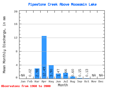
| Statistic | Jan | Feb | Mar | Apr | May | Jun | Jul | Aug | Sep | Oct | Nov | Dec | Annual |
|---|---|---|---|---|---|---|---|---|---|---|---|---|---|
| Mean | 0.00 | 0.71 | 3.00 | 0.94 | 0.35 | 0.40 | 0.14 | 0.04 | 0.03 | ||||
| Standard Deviation | 1.18 | 3.46 | 1.25 | 0.51 | 0.74 | 0.33 | 0.08 | 0.07 | |||||
| Min | 0.00 | 0.00 | 0.00 | 0.00 | 0.00 | 0.00 | 0.00 | 0.00 | 0.00 | ||||
| Max | 0.00 | 4.16 | 13.77 | 4.63 | 1.70 | 3.48 | 1.29 | 0.32 | 0.28 | ||||
| Coefficient of Variation | 1.65 | 1.16 | 1.34 | 1.43 | 1.88 | 2.30 | 2.17 | 2.12 |
 Return to R-Arctic Net Home Page