|
|
|||||||||||||||||
| Point ID: 5536 | Downloads | Plots | Site Data | Code: 05NB023 |
|
|
|||||||||||||||||
| Download | |
|---|---|
| Site Descriptor Information | Site Time Series Data |
| Link to all available data | |
| View: | Time Series | All |
| Units: | mm |
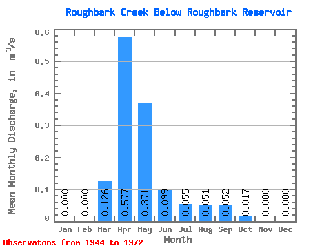
| Statistic | Jan | Feb | Mar | Apr | May | Jun | Jul | Aug | Sep | Oct | Nov | Dec | Annual |
|---|---|---|---|---|---|---|---|---|---|---|---|---|---|
| Mean | 0.00 | 0.00 | 0.13 | 0.58 | 0.37 | 0.10 | 0.06 | 0.05 | 0.05 | 0.02 | 0.00 | 0.00 | 0.11 |
| Standard Deviation | 0.26 | 0.90 | 0.70 | 0.17 | 0.05 | 0.08 | 0.07 | 0.04 | |||||
| Min | 0.00 | 0.00 | 0.00 | 0.00 | 0.00 | 0.00 | 0.00 | 0.00 | 0.00 | 0.00 | 0.00 | 0.00 | 0.11 |
| Max | 0.00 | 0.00 | 0.84 | 3.32 | 2.62 | 0.49 | 0.17 | 0.27 | 0.24 | 0.14 | 0.00 | 0.00 | 0.11 |
| Coefficient of Variation | 2.03 | 1.56 | 1.90 | 1.69 | 0.91 | 1.61 | 1.44 | 2.41 |
 Return to R-Arctic Net Home Page