|
|
|||||||||||||||||
| Point ID: 5536 | Downloads | Plots | Site Data | Code: 05NB023 |
|
|
|||||||||||||||||
| Download | |
|---|---|
| Site Descriptor Information | Site Time Series Data |
| Link to all available data | |
| View: | Time Series | All |
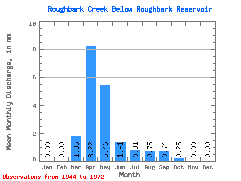
| Units: | m3/s |
| Statistic | Jan | Feb | Mar | Apr | May | Jun | Jul | Aug | Sep | Oct | Nov | Dec | Annual |
|---|---|---|---|---|---|---|---|---|---|---|---|---|---|
| Mean | 0.00 | 0.00 | 1.33 | 5.88 | 3.92 | 1.01 | 0.58 | 0.54 | 0.53 | 0.18 | 0.00 | 0.00 | 13.54 |
| Standard Deviation | 2.70 | 9.17 | 7.43 | 1.71 | 0.53 | 0.87 | 0.77 | 0.44 | |||||
| Min | 0.00 | 0.00 | 0.00 | 0.00 | 0.00 | 0.00 | 0.00 | 0.00 | 0.00 | 0.00 | 0.00 | 0.00 | 13.54 |
| Max | 0.00 | 0.00 | 8.87 | 33.88 | 27.62 | 5.02 | 1.83 | 2.81 | 2.48 | 1.51 | 0.00 | 0.00 | 13.54 |
| Coefficient of Variation | 2.03 | 1.56 | 1.90 | 1.69 | 0.91 | 1.61 | 1.44 | 2.41 |
 Return to R-Arctic Net Home Page