|
|
|||||||||||||||||
| Point ID: 5532 | Downloads | Plots | Site Data | Code: 05NB017 |
|
|
|||||||||||||||||
| Download | |
|---|---|
| Site Descriptor Information | Site Time Series Data |
| Link to all available data | |
| View: | Time Series | All |
| Units: | mm |
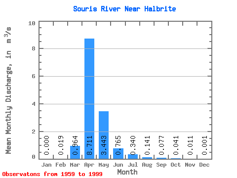
| Statistic | Jan | Feb | Mar | Apr | May | Jun | Jul | Aug | Sep | Oct | Nov | Dec | Annual |
|---|---|---|---|---|---|---|---|---|---|---|---|---|---|
| Mean | 0.00 | 0.02 | 0.96 | 8.71 | 3.44 | 0.77 | 0.34 | 0.14 | 0.08 | 0.04 | 0.01 | 0.00 | 1.58 |
| Standard Deviation | 0.00 | 0.04 | 1.66 | 13.12 | 6.62 | 2.26 | 0.64 | 0.47 | 0.18 | 0.06 | 0.01 | 0.00 | 1.70 |
| Min | 0.00 | 0.00 | 0.00 | 0.01 | 0.00 | 0.00 | 0.00 | 0.00 | 0.00 | 0.00 | 0.00 | 0.00 | 0.03 |
| Max | 0.00 | 0.11 | 7.14 | 53.10 | 32.70 | 13.70 | 2.62 | 2.78 | 1.02 | 0.30 | 0.03 | 0.00 | 3.74 |
| Coefficient of Variation | 2.65 | 2.06 | 1.73 | 1.51 | 1.92 | 2.95 | 1.89 | 3.30 | 2.35 | 1.46 | 1.02 | 1.13 | 1.08 |
 Return to R-Arctic Net Home Page