|
|
|||||||||||||||||
| Point ID: 5532 | Downloads | Plots | Site Data | Code: 05NB017 |
|
|
|||||||||||||||||
| Download | |
|---|---|
| Site Descriptor Information | Site Time Series Data |
| Link to all available data | |
| View: | Time Series | All |
| Units: | m3/s |
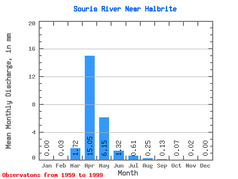
| Statistic | Jan | Feb | Mar | Apr | May | Jun | Jul | Aug | Sep | Oct | Nov | Dec | Annual |
|---|---|---|---|---|---|---|---|---|---|---|---|---|---|
| Mean | 0.00 | 0.01 | 0.81 | 7.08 | 2.89 | 0.62 | 0.28 | 0.12 | 0.06 | 0.03 | 0.01 | 0.00 | 15.67 |
| Standard Deviation | 0.00 | 0.03 | 1.40 | 10.66 | 5.56 | 1.83 | 0.54 | 0.39 | 0.15 | 0.05 | 0.01 | 0.00 | 16.86 |
| Min | 0.00 | 0.00 | 0.00 | 0.01 | 0.00 | 0.00 | 0.00 | 0.00 | 0.00 | 0.00 | 0.00 | 0.00 | 0.33 |
| Max | 0.00 | 0.09 | 5.99 | 43.15 | 27.45 | 11.13 | 2.20 | 2.33 | 0.83 | 0.26 | 0.03 | 0.00 | 37.04 |
| Coefficient of Variation | 2.65 | 2.06 | 1.73 | 1.51 | 1.92 | 2.95 | 1.89 | 3.30 | 2.35 | 1.46 | 1.02 | 1.13 | 1.08 |
 Return to R-Arctic Net Home Page