|
|
|||||||||||||||||
| Point ID: 5524 | Downloads | Plots | Site Data | Code: 05NB007 |
|
|
|||||||||||||||||
| Download | |
|---|---|
| Site Descriptor Information | Site Time Series Data |
| Link to all available data | |
| View: | Time Series | All |
| Units: | mm |
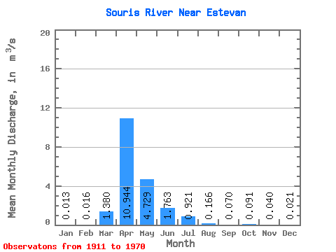
| Statistic | Jan | Feb | Mar | Apr | May | Jun | Jul | Aug | Sep | Oct | Nov | Dec | Annual |
|---|---|---|---|---|---|---|---|---|---|---|---|---|---|
| Mean | 0.01 | 0.02 | 1.38 | 10.94 | 4.73 | 1.76 | 0.92 | 0.17 | 0.07 | 0.09 | 0.04 | 0.02 | 1.55 |
| Standard Deviation | 0.02 | 0.02 | 2.51 | 14.72 | 8.19 | 3.64 | 3.04 | 0.43 | 0.11 | 0.19 | 0.05 | 0.03 | 1.59 |
| Min | 0.00 | 0.00 | 0.00 | 0.00 | 0.00 | 0.00 | 0.00 | 0.00 | 0.00 | 0.00 | 0.00 | 0.00 | 0.01 |
| Max | 0.10 | 0.07 | 10.00 | 62.30 | 41.50 | 22.30 | 20.30 | 2.67 | 0.39 | 1.15 | 0.18 | 0.11 | 5.94 |
| Coefficient of Variation | 1.69 | 1.36 | 1.82 | 1.34 | 1.73 | 2.07 | 3.31 | 2.58 | 1.59 | 2.10 | 1.31 | 1.33 | 1.03 |
 Return to R-Arctic Net Home Page