|
|
|||||||||||||||||
| Point ID: 5524 | Downloads | Plots | Site Data | Code: 05NB007 |
|
|
|||||||||||||||||
| Download | |
|---|---|
| Site Descriptor Information | Site Time Series Data |
| Link to all available data | |
| View: | Time Series | All |
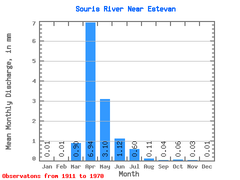
| Units: | m3/s |
| Statistic | Jan | Feb | Mar | Apr | May | Jun | Jul | Aug | Sep | Oct | Nov | Dec | Annual |
|---|---|---|---|---|---|---|---|---|---|---|---|---|---|
| Mean | 0.00 | 0.00 | 0.33 | 2.51 | 1.12 | 0.40 | 0.22 | 0.04 | 0.02 | 0.02 | 0.01 | 0.01 | 4.33 |
| Standard Deviation | 0.01 | 0.01 | 0.60 | 3.38 | 1.94 | 0.83 | 0.72 | 0.10 | 0.03 | 0.04 | 0.01 | 0.01 | 4.44 |
| Min | 0.00 | 0.00 | 0.00 | 0.00 | 0.00 | 0.00 | 0.00 | 0.00 | 0.00 | 0.00 | 0.00 | 0.00 | 0.01 |
| Max | 0.02 | 0.02 | 2.37 | 14.29 | 9.84 | 5.12 | 4.81 | 0.63 | 0.09 | 0.27 | 0.04 | 0.03 | 16.60 |
| Coefficient of Variation | 1.69 | 1.36 | 1.82 | 1.34 | 1.73 | 2.07 | 3.31 | 2.58 | 1.59 | 2.10 | 1.31 | 1.33 | 1.03 |
 Return to R-Arctic Net Home Page