|
|
|||||||||||||||||
| Point ID: 5521 | Downloads | Plots | Site Data | Code: 05NB001 |
|
|
|||||||||||||||||
| Download | |
|---|---|
| Site Descriptor Information | Site Time Series Data |
| Link to all available data | |
| View: | Time Series | All |
| Units: | mm |
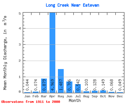
| Statistic | Jan | Feb | Mar | Apr | May | Jun | Jul | Aug | Sep | Oct | Nov | Dec | Annual |
|---|---|---|---|---|---|---|---|---|---|---|---|---|---|
| Mean | 0.04 | 0.07 | 0.88 | 4.97 | 1.49 | 0.71 | 0.54 | 0.10 | 0.13 | 0.15 | 0.07 | 0.05 | 0.80 |
| Standard Deviation | 0.10 | 0.22 | 2.58 | 8.09 | 3.37 | 1.84 | 1.71 | 0.18 | 0.45 | 0.40 | 0.13 | 0.11 | 1.23 |
| Min | 0.00 | 0.00 | 0.01 | 0.01 | 0.00 | 0.01 | 0.00 | 0.00 | 0.00 | 0.00 | 0.00 | 0.00 | 0.01 |
| Max | 0.74 | 1.49 | 16.20 | 39.40 | 21.00 | 10.50 | 12.20 | 1.06 | 3.40 | 2.22 | 0.70 | 0.73 | 5.99 |
| Coefficient of Variation | 2.36 | 3.00 | 2.93 | 1.63 | 2.27 | 2.61 | 3.17 | 1.80 | 3.51 | 2.70 | 1.96 | 2.21 | 1.53 |
 Return to R-Arctic Net Home Page