|
|
|||||||||||||||||
| Point ID: 5521 | Downloads | Plots | Site Data | Code: 05NB001 |
|
|
|||||||||||||||||
| Download | |
|---|---|
| Site Descriptor Information | Site Time Series Data |
| Link to all available data | |
| View: | Time Series | All |
| Units: | m3/s |
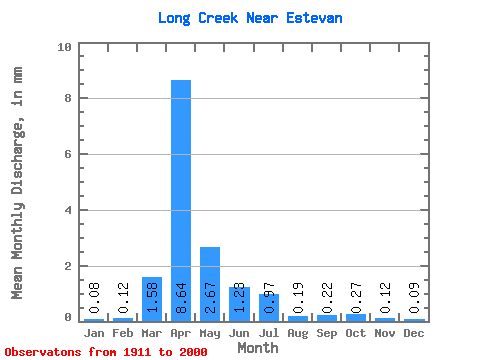
| Statistic | Jan | Feb | Mar | Apr | May | Jun | Jul | Aug | Sep | Oct | Nov | Dec | Annual |
|---|---|---|---|---|---|---|---|---|---|---|---|---|---|
| Mean | 0.02 | 0.04 | 0.49 | 2.66 | 0.82 | 0.38 | 0.30 | 0.06 | 0.07 | 0.08 | 0.04 | 0.03 | 5.23 |
| Standard Deviation | 0.06 | 0.11 | 1.43 | 4.33 | 1.87 | 0.99 | 0.95 | 0.10 | 0.24 | 0.22 | 0.07 | 0.06 | 8.02 |
| Min | 0.00 | 0.00 | 0.00 | 0.00 | 0.00 | 0.00 | 0.00 | 0.00 | 0.00 | 0.00 | 0.00 | 0.00 | 0.03 |
| Max | 0.41 | 0.75 | 8.96 | 21.10 | 11.62 | 5.62 | 6.75 | 0.59 | 1.82 | 1.23 | 0.37 | 0.41 | 39.05 |
| Coefficient of Variation | 2.36 | 3.00 | 2.93 | 1.63 | 2.27 | 2.61 | 3.17 | 1.80 | 3.51 | 2.70 | 1.96 | 2.21 | 1.53 |
 Return to R-Arctic Net Home Page