|
|
|||||||||||||||||
| Point ID: 5484 | Downloads | Plots | Site Data | Code: 05MA011 |
|
|
|||||||||||||||||
| Download | |
|---|---|
| Site Descriptor Information | Site Time Series Data |
| Link to all available data | |
| View: | Time Series | All |
| Units: | mm |
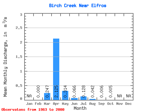
| Statistic | Jan | Feb | Mar | Apr | May | Jun | Jul | Aug | Sep | Oct | Nov | Dec | Annual |
|---|---|---|---|---|---|---|---|---|---|---|---|---|---|
| Mean | 0.00 | 0.25 | 2.12 | 0.31 | 0.07 | 0.13 | 0.04 | 0.01 | 0.01 | ||||
| Standard Deviation | 0.00 | 0.51 | 2.30 | 0.65 | 0.14 | 0.57 | 0.14 | 0.02 | 0.02 | ||||
| Min | 0.00 | 0.00 | 0.00 | 0.00 | 0.00 | 0.00 | 0.00 | 0.00 | 0.00 | ||||
| Max | 0.00 | 1.95 | 9.80 | 3.35 | 0.66 | 3.44 | 0.77 | 0.12 | 0.10 | ||||
| Coefficient of Variation | 2.08 | 1.08 | 2.06 | 2.15 | 4.43 | 3.38 | 3.38 | 3.09 |
 Return to R-Arctic Net Home Page