|
|
|||||||||||||||||
| Point ID: 5484 | Downloads | Plots | Site Data | Code: 05MA011 |
|
|
|||||||||||||||||
| Download | |
|---|---|
| Site Descriptor Information | Site Time Series Data |
| Link to all available data | |
| View: | Time Series | All |
| Units: | m3/s |
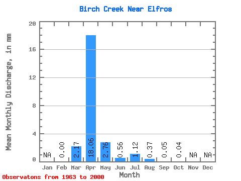
| Statistic | Jan | Feb | Mar | Apr | May | Jun | Jul | Aug | Sep | Oct | Nov | Dec | Annual |
|---|---|---|---|---|---|---|---|---|---|---|---|---|---|
| Mean | 0.00 | 0.95 | 7.96 | 1.22 | 0.25 | 0.49 | 0.16 | 0.02 | 0.02 | ||||
| Standard Deviation | 0.00 | 1.98 | 8.60 | 2.51 | 0.53 | 2.19 | 0.55 | 0.08 | 0.06 | ||||
| Min | 0.00 | 0.00 | 0.00 | 0.00 | 0.00 | 0.00 | 0.00 | 0.00 | 0.00 | ||||
| Max | 0.00 | 7.55 | 36.71 | 12.96 | 2.46 | 13.31 | 2.99 | 0.45 | 0.38 | ||||
| Coefficient of Variation | 2.08 | 1.08 | 2.06 | 2.15 | 4.43 | 3.38 | 3.38 | 3.09 |
 Return to R-Arctic Net Home Page