|
|
|||||||||||||||||
| Point ID: 5476 | Downloads | Plots | Site Data | Code: 05LB010 |
|
|
|||||||||||||||||
| Download | |
|---|---|
| Site Descriptor Information | Site Time Series Data |
| Link to all available data | |
| View: | Time Series | All |
| Units: | mm |
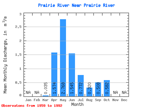
| Statistic | Jan | Feb | Mar | Apr | May | Jun | Jul | Aug | Sep | Oct | Nov | Dec | Annual |
|---|---|---|---|---|---|---|---|---|---|---|---|---|---|
| Mean | 0.04 | 1.57 | 2.77 | 1.54 | 0.77 | 0.32 | 0.51 | 0.58 | |||||
| Standard Deviation | 0.05 | 0.87 | 2.48 | 1.54 | 1.57 | 0.51 | 0.65 | 0.65 | |||||
| Min | 0.00 | 0.52 | 0.16 | 0.07 | 0.00 | 0.00 | 0.00 | 0.00 | |||||
| Max | 0.24 | 3.49 | 9.49 | 4.25 | 6.93 | 1.87 | 2.44 | 2.50 | |||||
| Coefficient of Variation | 1.52 | 0.55 | 0.90 | 1.00 | 2.03 | 1.59 | 1.27 | 1.11 |
 Return to R-Arctic Net Home Page