|
|
|||||||||||||||||
| Point ID: 5476 | Downloads | Plots | Site Data | Code: 05LB010 |
|
|
|||||||||||||||||
| Download | |
|---|---|
| Site Descriptor Information | Site Time Series Data |
| Link to all available data | |
| View: | Time Series | All |
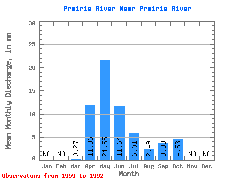
| Units: | m3/s |
| Statistic | Jan | Feb | Mar | Apr | May | Jun | Jul | Aug | Sep | Oct | Nov | Dec | Annual |
|---|---|---|---|---|---|---|---|---|---|---|---|---|---|
| Mean | 0.27 | 11.49 | 20.88 | 11.28 | 5.82 | 2.41 | 3.71 | 4.39 | |||||
| Standard Deviation | 0.40 | 6.34 | 18.71 | 11.26 | 11.82 | 3.84 | 4.72 | 4.87 | |||||
| Min | 0.00 | 3.76 | 1.19 | 0.47 | 0.01 | 0.02 | 0.00 | 0.00 | |||||
| Max | 1.79 | 25.48 | 71.59 | 31.03 | 52.28 | 14.11 | 17.82 | 18.86 | |||||
| Coefficient of Variation | 1.52 | 0.55 | 0.90 | 1.00 | 2.03 | 1.59 | 1.27 | 1.11 |
 Return to R-Arctic Net Home Page