|
|
|||||||||||||||||
| Point ID: 5475 | Downloads | Plots | Site Data | Code: 05LB009 |
|
|
|||||||||||||||||
| Download | |
|---|---|
| Site Descriptor Information | Site Time Series Data |
| Link to all available data | |
| View: | Time Series | All |
| Units: | mm |
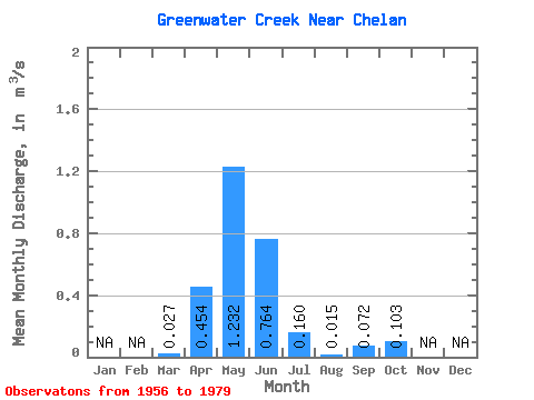
| Statistic | Jan | Feb | Mar | Apr | May | Jun | Jul | Aug | Sep | Oct | Nov | Dec | Annual |
|---|---|---|---|---|---|---|---|---|---|---|---|---|---|
| Mean | 0.03 | 0.45 | 1.23 | 0.76 | 0.16 | 0.01 | 0.07 | 0.10 | |||||
| Standard Deviation | 0.04 | 0.32 | 0.98 | 0.59 | 0.19 | 0.02 | 0.10 | 0.14 | |||||
| Min | 0.00 | 0.02 | 0.07 | 0.01 | 0.00 | 0.00 | 0.00 | 0.00 | |||||
| Max | 0.12 | 1.03 | 3.03 | 1.52 | 0.46 | 0.04 | 0.25 | 0.34 | |||||
| Coefficient of Variation | 1.55 | 0.70 | 0.80 | 0.77 | 1.21 | 1.35 | 1.43 | 1.40 |
 Return to R-Arctic Net Home Page