|
|
|||||||||||||||||
| Point ID: 5475 | Downloads | Plots | Site Data | Code: 05LB009 |
|
|
|||||||||||||||||
| Download | |
|---|---|
| Site Descriptor Information | Site Time Series Data |
| Link to all available data | |
| View: | Time Series | All |
| Units: | m3/s |
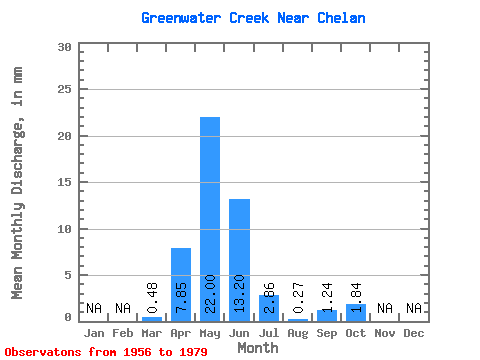
| Statistic | Jan | Feb | Mar | Apr | May | Jun | Jul | Aug | Sep | Oct | Nov | Dec | Annual |
|---|---|---|---|---|---|---|---|---|---|---|---|---|---|
| Mean | 0.33 | 5.37 | 15.07 | 9.04 | 1.96 | 0.19 | 0.85 | 1.26 | |||||
| Standard Deviation | 0.52 | 3.77 | 12.04 | 6.97 | 2.36 | 0.25 | 1.22 | 1.76 | |||||
| Min | 0.00 | 0.26 | 0.91 | 0.15 | 0.01 | 0.00 | 0.00 | 0.00 | |||||
| Max | 1.46 | 12.19 | 37.05 | 17.99 | 5.58 | 0.50 | 2.96 | 4.14 | |||||
| Coefficient of Variation | 1.55 | 0.70 | 0.80 | 0.77 | 1.21 | 1.35 | 1.43 | 1.40 |
 Return to R-Arctic Net Home Page