|
|
|||||||||||||||||
| Point ID: 5473 | Downloads | Plots | Site Data | Code: 05LB007 |
|
|
|||||||||||||||||
| Download | |
|---|---|
| Site Descriptor Information | Site Time Series Data |
| Link to all available data | |
| View: | Time Series | All |
| Units: | mm |
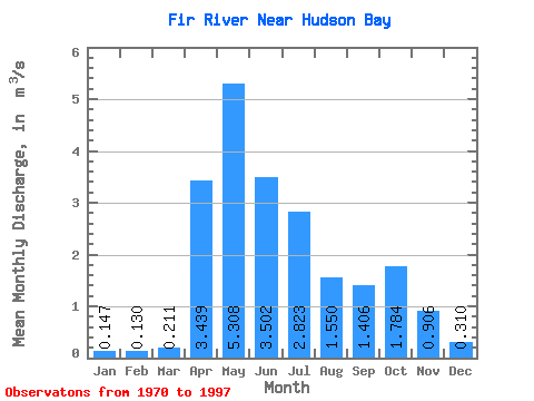
| Statistic | Jan | Feb | Mar | Apr | May | Jun | Jul | Aug | Sep | Oct | Nov | Dec | Annual |
|---|---|---|---|---|---|---|---|---|---|---|---|---|---|
| Mean | 0.15 | 0.13 | 0.21 | 3.44 | 5.31 | 3.50 | 2.82 | 1.55 | 1.41 | 1.78 | 0.91 | 0.31 | 1.65 |
| Standard Deviation | 0.07 | 0.10 | 0.22 | 1.91 | 3.64 | 2.44 | 2.64 | 1.58 | 1.13 | 1.27 | 0.67 | 0.17 | 0.57 |
| Min | 0.03 | 0.00 | 0.01 | 0.98 | 1.03 | 0.48 | 0.59 | 0.15 | 0.12 | 0.30 | 0.17 | 0.07 | 0.94 |
| Max | 0.28 | 0.47 | 1.12 | 8.42 | 14.30 | 9.67 | 12.70 | 6.18 | 4.97 | 5.40 | 2.57 | 0.61 | 2.64 |
| Coefficient of Variation | 0.49 | 0.81 | 1.03 | 0.55 | 0.69 | 0.69 | 0.93 | 1.02 | 0.81 | 0.71 | 0.74 | 0.54 | 0.35 |
 Return to R-Arctic Net Home Page