|
|
|||||||||||||||||
| Point ID: 5473 | Downloads | Plots | Site Data | Code: 05LB007 |
|
|
|||||||||||||||||
| Download | |
|---|---|
| Site Descriptor Information | Site Time Series Data |
| Link to all available data | |
| View: | Time Series | All |
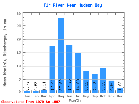
| Units: | m3/s |
| Statistic | Jan | Feb | Mar | Apr | May | Jun | Jul | Aug | Sep | Oct | Nov | Dec | Annual |
|---|---|---|---|---|---|---|---|---|---|---|---|---|---|
| Mean | 0.77 | 0.62 | 1.11 | 17.45 | 27.82 | 17.76 | 14.79 | 8.12 | 7.13 | 9.35 | 4.59 | 1.62 | 101.92 |
| Standard Deviation | 0.38 | 0.50 | 1.14 | 9.67 | 19.07 | 12.35 | 13.82 | 8.27 | 5.75 | 6.68 | 3.39 | 0.87 | 35.33 |
| Min | 0.13 | 0.01 | 0.08 | 4.98 | 5.40 | 2.44 | 3.11 | 0.77 | 0.58 | 1.55 | 0.88 | 0.37 | 58.20 |
| Max | 1.45 | 2.23 | 5.87 | 42.71 | 74.94 | 49.05 | 66.56 | 32.39 | 25.21 | 28.30 | 13.04 | 3.18 | 162.99 |
| Coefficient of Variation | 0.49 | 0.81 | 1.03 | 0.55 | 0.69 | 0.69 | 0.93 | 1.02 | 0.81 | 0.71 | 0.74 | 0.54 | 0.35 |
 Return to R-Arctic Net Home Page